Modern technology uses many sensors to detect objects and measure distance. Two common sensing technologies are radar or LiDAR. These systems help machines understand their surroundings.
They are widely used in cars, airplanes, weather monitoring, and navigation systems. Many modern vehicles, including self driving cars, use these technologies to improve safety and awareness.
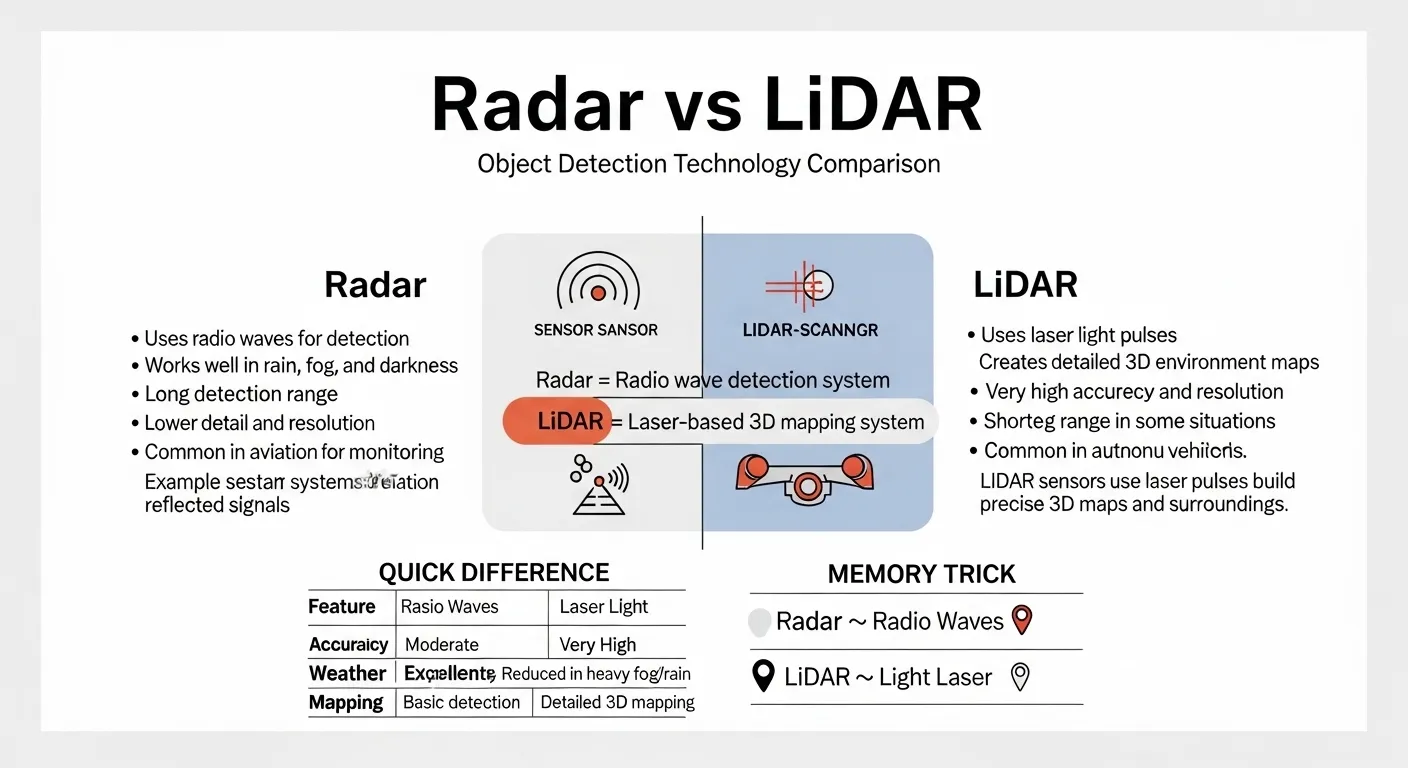
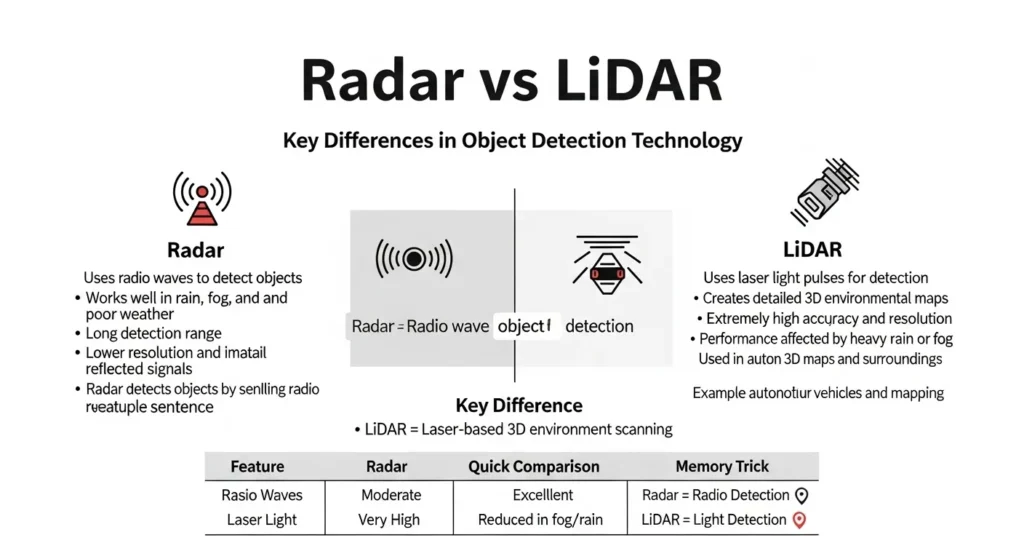
Radar works by sending radio waves into the environment. The waves bounce back after hitting objects. The system then measures the time it takes for the waves to return. This helps determine the distance and speed of objects.
LiDAR, on the other hand, uses laser light instead of radio waves. It sends laser pulses and measures how long they take to return. This process creates very detailed maps of the surroundings.
Understanding the difference between LiDAR and radar is important in fields like robotics, aviation, and autonomous vehicles.
In simple terms, radar uses radio waves to detect objects, while LiDAR uses laser light to create highly detailed 3D maps.
📖 Definitions
📻 Definition of Radar
Radar stands for Radio Detection or Ranging. It is a technology that uses radio waves to detect objects and measure their distance, direction, and speed.
Radar systems send out radio signals. When these signals hit an object, they bounce back to the radar receiver.
By calculating the time taken for the signal to return, the system can determine how far away the object is.
Radar works well in different weather conditions. Rain, fog, and darkness usually do not affect radio waves much.
Because of this, radar is commonly used in aviation, military systems, weather monitoring, and vehicle safety systems.
Radar is also used in speed detection devices and air traffic control systems. It helps track aircraft and ships from long distances.
Example:
Weather stations use radar to track storms and detect rainfall patterns.
🔦 Definition of LiDAR
LiDAR stands for Light Ranging and Detection. It is a sensing technology that uses laser light to measure distance and create detailed 3D maps of the environment.
LiDAR systems send out thousands or even millions of laser pulses every second. These pulses hit objects and reflect back to the sensor. By measuring the return time, the system calculates the exact distance of each object.
Because LiDAR uses laser light, it can create very accurate and detailed images of surroundings. This makes it extremely useful in mapping, robotics, archaeology, and autonomous vehicles.
LiDAR technology is also used in drones and satellites to create precise maps of terrain and buildings.
Example:
Autonomous cars use LiDAR to build a detailed 3D map of the road and nearby obstacles.
🔍 Key Differences Between Radar and LiDAR
1️⃣ Type of Signal
Radar:
Radar uses radio waves to detect objects.
LiDAR:
LiDAR uses laser light pulses to measure distance.
2️⃣ Accuracy
Radar:
Radar provides good distance detection but lower image detail.
LiDAR:
LiDAR provides extremely high accuracy and detailed mapping.
3️⃣ Mapping Capability
Radar:
Radar mainly detects the presence and speed of objects.
LiDAR:
LiDAR creates detailed 3D maps of the environment.
4️⃣ Weather Performance
Radar:
Radar works well in rain, fog, and poor weather conditions.
LiDAR:
LiDAR performance can be reduced in heavy rain, fog, or dust.
5️⃣ Range
Radar:
Radar can detect objects at long distances.
LiDAR:
LiDAR usually has shorter detection ranges compared to radar.
6️⃣ Resolution
Radar:
Radar has lower resolution and less detailed images.
LiDAR:
LiDAR provides high resolution environmental data.
7️⃣ Cost
Radar:
Radar systems are usually cheaper.
LiDAR:
LiDAR systems are often more expensive due to advanced laser technology.
8️⃣ Common Applications
Radar:
Used in aviation, weather forecasting, military systems, and speed detection.
LiDAR:
Used in autonomous vehicles, robotics, mapping, and terrain scanning.
9️⃣ Technology Complexity
Radar:
Radar technology is simpler and widely established.
LiDAR:
LiDAR systems are more complex and advanced.
🔟 Key Difference Summary
Radar:
Uses radio waves
Works well in bad weather
Long detection range
Lower detail and resolution
Usually cheaper
LiDAR:
Uses laser light
Creates detailed 3D maps
Higher accuracy
Shorter range in some cases
Usually more expensive
🏁 Conclusion
Radar and LiDAR are both powerful sensing technologies used to detect objects and measure distance.
Although they perform similar functions, they use different types of signals and provide different levels of detail.
Radar uses radio waves and is known for its ability to work reliably in poor weather conditions. It can detect objects at long distances and is widely used in aviation, weather monitoring, and military systems.
LiDAR uses laser light pulses to measure distances. This allows it to create very accurate and detailed 3D maps of the environment.
Because of this capability, LiDAR is widely used in autonomous vehicles, mapping projects, and robotics.
Another important difference is cost and complexity. Radar systems are generally cheaper and simpler. LiDAR systems are more advanced and usually more expensive because of the laser technology involved.
In modern technology, both radar and LiDAR often work together. For example, self driving cars may use radar to detect distant objects and LiDAR to create detailed maps of nearby surroundings.
In simple terms, radar is better for long range detection and reliability in bad weather, while LiDAR is better for high precision mapping and detailed environmental scanning.
Discover More Articals!
📄 Difference Between 10K VS 10Q: Simple and Clear Guide
🥢 Difference Between Bao and Dumpling With In 30 Seconds
💰 Difference Between AML and KYC: Simple and Clear Guide

James Whitmore. Labdiff.com is my english grammar comparision website. I explore the history and evolution of English words. I write detailed comparisons explaining why spellings change over time and how British and American English diverged. My articles add depth and credibility to grammar comparison topics.